UAS Services

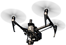
ADS operates a DJI Inspire2 UAV (drone) with the Zenmuse X4S 20MP camera, augmented with a specialized high-precision, direct-geopositioning GNSS package for precision image geo-referencing and mapping applications. The X4S camera mounts in a stabilized gimbal and employs a mechanical shutter to eliminate image distortion and captures images in a variety of formats and aspect ratios with a maximum FOV of 84°. The flexibility of a small UAS platform and gimbaled camera system allow for near-unlimited imaging angles of the object/area of interest.
Our UAS services provide a flexible toolset to deliver engineering grade data for specialized projects at a fraction of the cost of traditional acquisition methods. These services are well-suited to the key areas of the following industries:
- Asset documentation, inventory & lifecycle management
- Infrastructure/Component condition & health inspection
- Baselining & monitoring right-of-way encroachments/obstructions/changes
- Field site and refinery component inspection
- Environmental & safety compliance confirmation
- Site preparation, mapping, and change monitoring
- Asset inventory & management
- Site surveying & volumetric measurements
- Traffic planning & management
- Geo-referenced features and planimetric data that meet established accuracy standards
- Orthorectified imagery for site planning and progress monitoring
- Site Digital Elevation Model (DEM) and contour data
ADS delivers data products in a variety of industry-standard formats, readily compatible for viewing or processing in other engineering applications. This data is provided directly to the client, requiring no web-based viewing constraints or 3rd party management – A critical component to ensuring data integrity and accessibility. As the use of UAS becomes more prevalent, it is imperative for the end-user to have the utmost confidence not only in the data, but also pedigree of the service provider. Our experienced staff, state-of-the-art processing suites, and rigorous quality control processes ensure the final product deliverables are accurate, complete, and actionable.