CITY OF FORT SMITH, ARKANSAS
MUNICIPAL MAPPING
Aerial Data Service, Inc. (ADS) provided citywide surveying and mapping services for the City of Fort Smith, Arkansas. The initial phase of aerial photography and digital mapping was completed in 2004. When the City determined that an update of the citywide mapping was needed, they selected ADS as the most qualified firm out of nineteen geospatial firms vying for the contract.
In 2014, ADS was contracted to begin aerial photography and updated mapping of the city. ADS provided new aerial photography, ground control and updated digital mapping, and digital orthophotos. The project was funded with revenue from a city sales tax for streets, bridges and drainage. According to the City of Fort Smith, the geospatial information was instrumental for economic development when site-selectors were looking at communities.
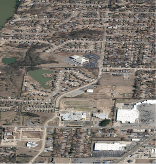
New color aerial photography was obtained for approximately ninety-four (94) square miles of the project area that included the city and extra territorial jurisdictional area to the south. The photography was obtained at an altitude of 3,200’ above mean terrain (AMT). Two base stations and twenty (20) checkpoints were provided to ensure proper ground control was maintained.
Full analytical aerotriangulation was performed to extend control throughout the project photography for digital mapping. Digital data was collected at a 1” = 100’ scale for planimetric features that were identifiable on, or interpretable from, the aerial photographs. Digital terrain model (DTM) data was collected in a manner that accurately depicted the terrain, and contours at 2’ intervals were developed from the DTM data. All cultural, transportation, utilities, hydrology, elevation (DEM/DTM), and vegetation feature classes were collected using 3D imagery while maintaining the spatial and topologic relationships in an ArcGIS Geodatabase format. Mapping entailed terrain and cultural features such as drainage features, power lines, various building, bridges, and transportation networks. Digital mapping data was delivered in AutoCAD format and color digital orthophotos with a 0.25’ pixel resolution were delivered in TIF/TFW and MrSid formats.
In an evaluation of the project from Mr. Matt Meeker, who was the Project Manager for the City of Fort Smith, Aerial Data Service received all exceptional ratings for the categories of work questioned, including quality, schedule/timeliness of performance, customer satisfaction, management/personnel/labor and safety/security.